Wednesday, September 10, 2014
Hell Corner
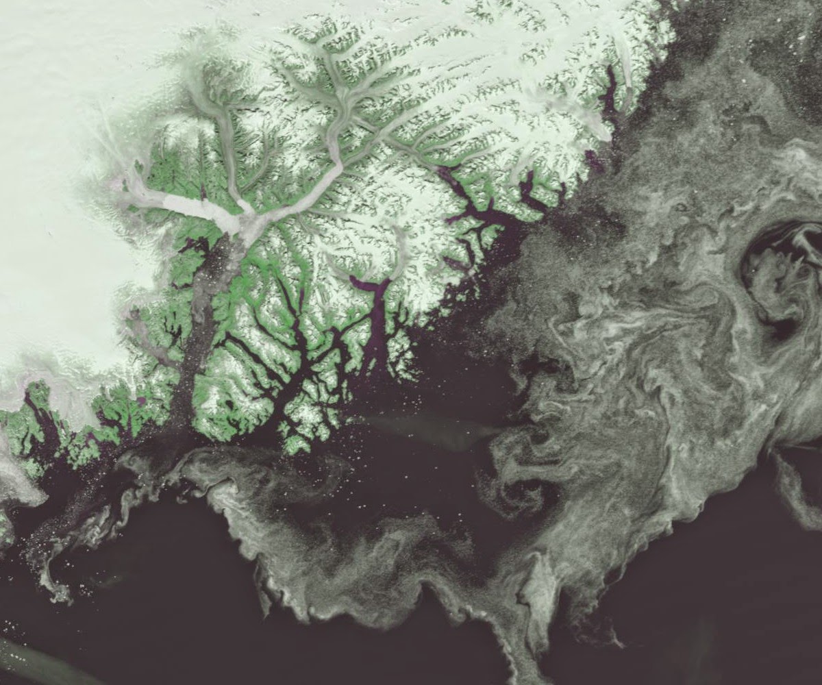
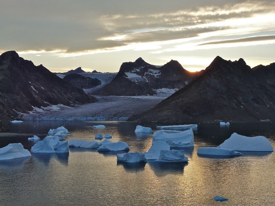
The team rose early soon after the sun rose into the blue morning sky. The sea was calmer and the weather forecast favourable. The northern tip of Storø is around 10 kilometres across a wide channel from the beginning of a 30 kilometre stretch of coastline dubbed 'Hell Corner' by Watkins' 1930s expeditions.
The closer we got the greater the swell became. As we approached the first major headland the waters became choppier than we had seen on this trip. Several huge bergs that were surging in the swell gave us only limited room to get through, or around.
Normally, there would also be bands of pack ice sitting just offshore. The presence of pack ice serves as a slowly drifting breakwater and dampens off much of the energy from the swell. It is also possible to land on these flat fragments of frozen ocean to rest on long passages. On this occasion the pack ice was gone. Only huge bergs remained leaving our route around 'Hell Corner' exposed to the undiluted power of the Denmark Strait.
There group had gone a bit quiet. There was none of the usual chatty banter. A decision needed to be made and agreed upon so we rafted up. Even holding the kayaks together was tricky as they banged together in the surging choppy sea. With a further 30 kilometres of committing paddling to go, there was insufficient confidence to go ahead, especially as we had only a vague forecast for the return. Reluctantly, we decided to retreat to a beach that we had passed some 40 minutes earlier.
We landed through surf onto a broad pebbly beach in a bay that was littered ice fragments. We took our time to eat, rest and recuperate. If we were to abandon our plans to reach Tugtilik, we would need to identify a new objective. In the meantime, somewhere to camp would be good too...
Sunday, September 07, 2014
Storø
Having filled up our water containers from some melting snowpack on Depot Island, a gentle southerly breeze followed us out of the channel that led out to the open sea. The ocean swell was powerful as it crashed into the foot of the huge cliffs and surged around huge icebergs.
Progressively choppy seas greeted us at each new headland and as we paddled into shadow it felt progressively cold too.
It was with a great sense of relief that we reached the southern tip of Storø at around 6pm. Storø means big island in Danish and with its towering peaks and ridges reaching to over 800 metres it certainly lives up to its name.
Our relief was short-lived as we realized that our camp for the night in one of the northern bays was still over 2 hours paddling away. The warmth of the sun had all but gone by the time of our arrival. Fortunately, the 2 hunting cabins that we had been told about were in reasonably good condition so there was no need for us to pitch any tents. There were also some scraps of wood so we quickly made a fire. This not only kept the evening chill at bay but meant that we could save fuel by cooking on it.
Progressively choppy seas greeted us at each new headland and as we paddled into shadow it felt progressively cold too.
It was with a great sense of relief that we reached the southern tip of Storø at around 6pm. Storø means big island in Danish and with its towering peaks and ridges reaching to over 800 metres it certainly lives up to its name.
Our relief was short-lived as we realized that our camp for the night in one of the northern bays was still over 2 hours paddling away. The warmth of the sun had all but gone by the time of our arrival. Fortunately, the 2 hunting cabins that we had been told about were in reasonably good condition so there was no need for us to pitch any tents. There were also some scraps of wood so we quickly made a fire. This not only kept the evening chill at bay but meant that we could save fuel by cooking on it.
Friday, September 05, 2014
Depot Island
The early morning sunshine took its time spilling over the hill onto our west-facing camp. By the time we felt the sun's warmth, the glaciers across the water shining in its brilliance for more than 2 hours.
Smooth waters and light winds welcomed us onto the sea under a brilliant Arctic blue sky. Half way to our lunch stop we past some small islands and skerries. Out across the shimmering sea yet another island chain with towering peaks stretched into the sky. These chains of off-lying islands gave our passage a great deal of protection from the powerful swell in the Denmark Strait.
The further we paddled North, the more gigantic the coastline became. To the west lay deep inlets with calving glaciers stretching way inland. As we rounded the last major headland before our lunch stop on Depot Island, a chilly breeze began to creep in from the North. At first I thought that it may be one of those temporary gentle gusts that would last a few minutes. The breeze gained momentum until it was a steady force 4 scattering white-caps all around us. We altered course to get some shelter behind the headland on Depot Island that would be our lunch stop.
We scratched our way around the most easterly point onto a narrow pebbly beach. Realising that we would be there until the wind dropped, we got out our stoves and made plenty of steaming hot drinks. In the meantime 2 of the group who had plenty of energy continued around the north part of the island to scout ahead and look for water.
The wind continued for the rest of the day occasionally switching direction. Sometimes it would be Easterly and sometimes from the south. Either way, our lunch stop soon became our camp for the night. There was adequate space for tents but the pebbly beach that we had landed on at low water soon became flooded at the water rose. It was difficult to tell exactly how high the water would come and we ended up repeatedly shifting our kayaks higher and higher up the rocks until the time for high water has passed.
Smooth waters and light winds welcomed us onto the sea under a brilliant Arctic blue sky. Half way to our lunch stop we past some small islands and skerries. Out across the shimmering sea yet another island chain with towering peaks stretched into the sky. These chains of off-lying islands gave our passage a great deal of protection from the powerful swell in the Denmark Strait.
The further we paddled North, the more gigantic the coastline became. To the west lay deep inlets with calving glaciers stretching way inland. As we rounded the last major headland before our lunch stop on Depot Island, a chilly breeze began to creep in from the North. At first I thought that it may be one of those temporary gentle gusts that would last a few minutes. The breeze gained momentum until it was a steady force 4 scattering white-caps all around us. We altered course to get some shelter behind the headland on Depot Island that would be our lunch stop.
We scratched our way around the most easterly point onto a narrow pebbly beach. Realising that we would be there until the wind dropped, we got out our stoves and made plenty of steaming hot drinks. In the meantime 2 of the group who had plenty of energy continued around the north part of the island to scout ahead and look for water.
The wind continued for the rest of the day occasionally switching direction. Sometimes it would be Easterly and sometimes from the south. Either way, our lunch stop soon became our camp for the night. There was adequate space for tents but the pebbly beach that we had landed on at low water soon became flooded at the water rose. It was difficult to tell exactly how high the water would come and we ended up repeatedly shifting our kayaks higher and higher up the rocks until the time for high water has passed.
Monday, September 01, 2014
Stepping Off
There had been a steady breeze from the sea since we landed. This brought a penetrating chill that reminded me that we were in a lonely Arctic wilderness. I had been cold all night. I was woken at 5am for my hour long 'bearwatch' shift. I made myself a cup of hot chocolate and huddled behind a boulder whilst watching, waiting and hoping for nothing to happen. After my shift, I felt the benefit of the warm drink and got a couple of more hours in the land of nod.
Paddling from our first camp filled us with excitement and anticipation. The wind had abated, the morning sun warmed the air and gave the bergs a bright, fresh new look. The peak of the first exposed headland towered nearly 700 metres over the calm ocean. The sheer scale of the scenery was difficult to comprehend. We didn't land until lunchtime.
The rest of the day's paddle was less exposed with the sparkling coastal waters protected by a series of off-lying islands with peaks rising sharply to over 500 metres. We landed in the late afternoon sunshine on a sandy beach at the island of Gruse. To the east there was only open ocean with small groups of icebergs.
To the west, the steep mountainous coastline was dissected by immense
calving glaciers. Every now and then, a huge piece the size of a block of
flats would crash into the sea. This would give a thunderous boom shattering the peace of what had become a still and silent evening.
In the distance to the north we could make out Ailsa Island and our crux headland dubbed 'Hell Corner' by the 1932 British Air Route Expedition team. We were stepping off into territory where few choose to venture.
Paddling from our first camp filled us with excitement and anticipation. The wind had abated, the morning sun warmed the air and gave the bergs a bright, fresh new look. The peak of the first exposed headland towered nearly 700 metres over the calm ocean. The sheer scale of the scenery was difficult to comprehend. We didn't land until lunchtime.
The rest of the day's paddle was less exposed with the sparkling coastal waters protected by a series of off-lying islands with peaks rising sharply to over 500 metres. We landed in the late afternoon sunshine on a sandy beach at the island of Gruse. To the east there was only open ocean with small groups of icebergs.
In the distance to the north we could make out Ailsa Island and our crux headland dubbed 'Hell Corner' by the 1932 British Air Route Expedition team. We were stepping off into territory where few choose to venture.
Sunday, August 31, 2014
Arriving at Sermiligaaq
The flight from Reykjavik to Kulusuk Airport takes around an hour an forty minutes. Just over half way through the flight we began to see the jagged frozen coast of East Greenland. As we got close we could pick out some of the headlands and islands that we would be paddling round in the next 16 days.
When we landed we needed to get to the boat jetty which is around a kilometre walk from the airfield. Each of us were carrying around 30-40 kilograms of equipment and food.
The boat journey to Sermiligaaq took just over 90 minutes. Once we arrived there was no time to hang around. The first job was to get to the shop to buy some extra food. I bought bread, cheese, some tinned fish and as many beers as I though I could cram into an already heavily laden kayak. The second job was to get re-aquainted with the P&H Scorpio that I paddled in the 2012 expedition.
Once we were all loaded up we launched into a misty afternoon and paddled for just after an hour until reaching our first camp. After pitching my tent I went for a short walk around the nearby headland and gazed at the moon rising over the ice laden channel that we would be paddling through next morning. It really felt as though we were about to paddle off the edge of the world.
When we landed we needed to get to the boat jetty which is around a kilometre walk from the airfield. Each of us were carrying around 30-40 kilograms of equipment and food.
The boat journey to Sermiligaaq took just over 90 minutes. Once we arrived there was no time to hang around. The first job was to get to the shop to buy some extra food. I bought bread, cheese, some tinned fish and as many beers as I though I could cram into an already heavily laden kayak. The second job was to get re-aquainted with the P&H Scorpio that I paddled in the 2012 expedition.
Once we were all loaded up we launched into a misty afternoon and paddled for just after an hour until reaching our first camp. After pitching my tent I went for a short walk around the nearby headland and gazed at the moon rising over the ice laden channel that we would be paddling through next morning. It really felt as though we were about to paddle off the edge of the world.
Thursday, August 28, 2014
Reykjavik, the gateway to East Greenland
East Greenland is just as easily reached and many of the remote yet popular holiday destinations in Europe. The total flying time is a little over 4 hours. Flights from Reykjavik to Kulusuk only run in the morning so the journey will always involve an overnight stay in Iceland's intriguing capital city.
Reykjavik is home to a community of prolific creators. Music, entertainment and art fills the busy public places but walking the narrow back streets it is clear that there is fresh talent growing at every corner.
My favourite sculpture is 'Sun Voyager' which is situated on the sea front close to the city centre. It is a ship of dreams, fantasy and knowledge. To sail the 'Sun Voyager' is to follow the sun and promises a bright future full of adventures and discovery.
All too soon the sightseeing is over and its is time for an early night. The next day will take us on a flight across the Denmark Strait to Kulusuk Airport and the beginning of our sea kayak journey in the tiny hunting community of Sermiligaaq on the icy East coast of Greenland.
| Sun Voyager (Icelandic: Sólfar) |
My favourite sculpture is 'Sun Voyager' which is situated on the sea front close to the city centre. It is a ship of dreams, fantasy and knowledge. To sail the 'Sun Voyager' is to follow the sun and promises a bright future full of adventures and discovery.
All too soon the sightseeing is over and its is time for an early night. The next day will take us on a flight across the Denmark Strait to Kulusuk Airport and the beginning of our sea kayak journey in the tiny hunting community of Sermiligaaq on the icy East coast of Greenland.
Thursday, August 07, 2014
Greenland here we come!
During the last few weeks I have been sending daily weather forecasts and information about the sea ice to Martin Rickard. He has been exploring the Fjords and channels of the Angmagssalik region of East Greenland.
Very soon it will be my turn to head off to this dramatic Arctic coastline. Our expedition will take us along a more exposed stretch of coastline to a place called Tugtilik otherwise known as Lake Fjord. This is where the celebrated British explorer, Gino Watkins went missing in August 1932. A memorial cross stands in his honour close to the remains of his expedition hut.
Back home I have been weighing my kit and checking my documents. Thanks to Lyon Equipment I have a new set of Ortlieb dry bags and 2 weeks supply of Trek 'n Eat freeze dried expedition meals. Once again I have plenty of nutritious Clif Bars that will help keep me going on those long days on the sea.
It has been a challenge getting everything packed within the various airline weight limits, but its all coming together now. I'd like to take this opportunity to thank P&H Custom Sea Kayaks, Peak UK, F-stop Gear for their continued support as well as Mitchell Blades for my newly re-furbished 4-piece paddles.
Very soon it will be my turn to head off to this dramatic Arctic coastline. Our expedition will take us along a more exposed stretch of coastline to a place called Tugtilik otherwise known as Lake Fjord. This is where the celebrated British explorer, Gino Watkins went missing in August 1932. A memorial cross stands in his honour close to the remains of his expedition hut.
Back home I have been weighing my kit and checking my documents. Thanks to Lyon Equipment I have a new set of Ortlieb dry bags and 2 weeks supply of Trek 'n Eat freeze dried expedition meals. Once again I have plenty of nutritious Clif Bars that will help keep me going on those long days on the sea.
It has been a challenge getting everything packed within the various airline weight limits, but its all coming together now. I'd like to take this opportunity to thank P&H Custom Sea Kayaks, Peak UK, F-stop Gear for their continued support as well as Mitchell Blades for my newly re-furbished 4-piece paddles.
Tuesday, July 22, 2014
Skerries in the Mist
Following the great rains of Saturday, I joined members of Liverpool Canoe Club on a trip out to The Skerries off the North West coast of Anglesey. We launched at Cemlyn Bay where there was a gentle breeze and the sun was shining brightly.
As we left the bay we noticed the The Skerries were missing! We paddled into mist and dense fog patches. These weather conditions kept us guessing and focused on our navigation skills. However, past training and practice paid off as the islands loomed out of the gloom with around a kilometre to go.
Life on The Skerries is as hectic as ever. Most of the young Arctic Terns have now fledged but parent birds are still being kept busy feeding some of the younger ones.
A handful of chicks have yet to get their flight feathers. These late comers to the party will have to grow up fast if they are to be strong enough to make the long Autumn migration to the South Atlantic in the next 4-6 weeks.
In the meantime, life in the waters and around the rocks is busy for the seals. There was hardly a dull moment as we were escorted off the premises by several of these playful, inquisitive sea creatures.
The mist and fog patches remained for our return crossing. As we arrived back at the Anglesey shoreline, we took the opportunity to explore the gullies and channels that lead the way from Hen Borth to Cemlyn Bay. Many thanks again to my friends at Liverpool Canoe Club for their company over the weekend.
As we left the bay we noticed the The Skerries were missing! We paddled into mist and dense fog patches. These weather conditions kept us guessing and focused on our navigation skills. However, past training and practice paid off as the islands loomed out of the gloom with around a kilometre to go.
Life on The Skerries is as hectic as ever. Most of the young Arctic Terns have now fledged but parent birds are still being kept busy feeding some of the younger ones.
A handful of chicks have yet to get their flight feathers. These late comers to the party will have to grow up fast if they are to be strong enough to make the long Autumn migration to the South Atlantic in the next 4-6 weeks.
In the meantime, life in the waters and around the rocks is busy for the seals. There was hardly a dull moment as we were escorted off the premises by several of these playful, inquisitive sea creatures.
The mist and fog patches remained for our return crossing. As we arrived back at the Anglesey shoreline, we took the opportunity to explore the gullies and channels that lead the way from Hen Borth to Cemlyn Bay. Many thanks again to my friends at Liverpool Canoe Club for their company over the weekend.
Monday, July 14, 2014
A return to Bardsey
Trevor an I set off from a misty scene on Aberdaron beach. Initially we headed fro the East side of the bay where we found some entertaining paddling in the caves and amongst the rock gardens.
The poor visibility gave us some concern about the 7km crossing to Bardsey from Ynys Gwylan Bach. In addition, we would be dealing with strong currents generated by strong spring tides.
During the crossing we were entertained by local puffins and spectacular aerial displays of Manx shearwaters as they glided across the sea around us, skimming the tops of the waves. I'm sure they were playing a game of 'dodge the kayak' flying to within feet of our bows.
The crossing took more time and effort than we expected. We were reminded that the crossing to Bardsey is one of the more challenging sort crossings in the UK.
Down on the western pastures the sheep shearers have been and the hay has been cut too. However, one of the fields has been left as a spectacular summer meadow.
Walking along the summit ridge of Mynydd Enlli, we were treated to yet more wild wonders. Mountain thyme is now in flower among the rocks, peregrines are busy feeding their young on the young of other unwary parents and the local gang of adolescent choughs are up to no good as usual.
Our return to Aberdaron was far more straight forward in good visibility and glorious sunshine.
The poor visibility gave us some concern about the 7km crossing to Bardsey from Ynys Gwylan Bach. In addition, we would be dealing with strong currents generated by strong spring tides.
During the crossing we were entertained by local puffins and spectacular aerial displays of Manx shearwaters as they glided across the sea around us, skimming the tops of the waves. I'm sure they were playing a game of 'dodge the kayak' flying to within feet of our bows.
The crossing took more time and effort than we expected. We were reminded that the crossing to Bardsey is one of the more challenging sort crossings in the UK.
Down on the western pastures the sheep shearers have been and the hay has been cut too. However, one of the fields has been left as a spectacular summer meadow.
Walking along the summit ridge of Mynydd Enlli, we were treated to yet more wild wonders. Mountain thyme is now in flower among the rocks, peregrines are busy feeding their young on the young of other unwary parents and the local gang of adolescent choughs are up to no good as usual.
Our return to Aberdaron was far more straight forward in good visibility and glorious sunshine.
Monday, June 23, 2014
Under Sail
Last week I joined Dr Charles Clarke and his partner Marcella for a 3-day coastal voyage aboard his 35ft yacht 'Whisky Galore'.
Within an hour of leaving Pwllheli Harbour there were Manx shearwaters gliding along the wave crests. Soon afterwards we spotted a bottlenose dolphin, or perhaps it spotted us. Within minutes there were several of them playing in our bow wave.
Shore leave took us to venture round the pretty villages of Barmouth and Aberdovey. Each evening we were treated to lovely views across shallow estuarine waters to rolling hills and mountains beyond.
Many thanks to Charlie and Marcella for the adventure, great company and wonderful hospitality.
Within an hour of leaving Pwllheli Harbour there were Manx shearwaters gliding along the wave crests. Soon afterwards we spotted a bottlenose dolphin, or perhaps it spotted us. Within minutes there were several of them playing in our bow wave.
Shore leave took us to venture round the pretty villages of Barmouth and Aberdovey. Each evening we were treated to lovely views across shallow estuarine waters to rolling hills and mountains beyond.
Many thanks to Charlie and Marcella for the adventure, great company and wonderful hospitality.
Friday, June 20, 2014
Sea Kayak Expedition Gathering - Northumberland 2014
The Sea Kayak Expedition Gathering is a weekend of discussing and developing skills and techniques in preparation for expedition paddling.
This years gathering was based at The Barn at Beal in the rolling Northumberland countryside that overlooks the Holy Island of Lindisfarne.
The calm weather was too good to ignore. Workshops were all water-based and delivered as a series of 'top tips' whilst on the move and exploring the nearby Farne Islands.
In the late afternoon sunshine, all of the teams gathered on the Inner Farne to meet one of the wardens and get acquainted with the local wildlife. We all came away understanding the importance of wearing a hat when moving through an Arctic tern colony.
Saturday evening was more relaxed with plenty to drink, barbecued food and an inspiring talk by Olly Sanders.
Following the broad brush approach of the first day, Sunday's workshops were more focussed on boat handling, launching and landing in challenging conditions, and trip planning.
This years gathering was based at The Barn at Beal in the rolling Northumberland countryside that overlooks the Holy Island of Lindisfarne.
The calm weather was too good to ignore. Workshops were all water-based and delivered as a series of 'top tips' whilst on the move and exploring the nearby Farne Islands.
In the late afternoon sunshine, all of the teams gathered on the Inner Farne to meet one of the wardens and get acquainted with the local wildlife. We all came away understanding the importance of wearing a hat when moving through an Arctic tern colony.
Saturday evening was more relaxed with plenty to drink, barbecued food and an inspiring talk by Olly Sanders.
Following the broad brush approach of the first day, Sunday's workshops were more focussed on boat handling, launching and landing in challenging conditions, and trip planning.
Wednesday, June 11, 2014
Coquet Island Race
On the day before the Coquet Island Race John and I headed out to the Farne Islands to get in amongst the wildlife. Puffins, razorbills, guillemots and kittiwakes are in the middle of the busiest part of their breeding season.
On Staple Island and the Inner Farne, the Terns and Shags are at their grumpiest when visitors come on the tour boats from Seahouses.
Sunday morning was race day and the usual informal friendly atmosphere greeted competitors and spectators alike.
Winning times for the 5.5 mile course are always well under an hour. The first place in the men's race went to Brian Turnbull from the Scottish Borders.
First lady was (not for the the first time) Kate Duffus. Congratulations are due to all competitors but most of all thanks to Vic Brown and Coquet Canoe Club for this lovely event.
On Staple Island and the Inner Farne, the Terns and Shags are at their grumpiest when visitors come on the tour boats from Seahouses.
Sunday morning was race day and the usual informal friendly atmosphere greeted competitors and spectators alike.
Winning times for the 5.5 mile course are always well under an hour. The first place in the men's race went to Brian Turnbull from the Scottish Borders.
First lady was (not for the the first time) Kate Duffus. Congratulations are due to all competitors but most of all thanks to Vic Brown and Coquet Canoe Club for this lovely event.
Subscribe to:
Posts (Atom)