Saturday, September 13, 2008

The Middle (north) East

North Yorkshire (Sunday)

I met with Richard at Saltburn by the Sea to investigate the surf conditions that are well thought of in the region. The messy conditions were already being endured by many so we decided to head off for quieter and cleaner conditions elsewhere. Skinningrove, where the fishing fleet are celebrated with this fine monument, looked gloomy and messy too so we decided to descend upon quieter cleaner conditions at Runswick Bay.


Teeside (Monday)


Our presence along the coasts of Redcar, Teesmouth, Seaton and Hartlepool were met with comic suspicion and a relentless supply of 'John Darwin' jocularity. I came to the conclusion that the main attraction to paddling from Saltburn to Hartlepool is avoiding the traffic chaos of Teeside. After visiting the ancient semi submerged wreck at Seaton Carew beach we went in search of enlightenment at the dockside Museum Of Hartlepool. Following our taxing day off the water we found refuge at the Crimdon Dene Caravan Park north of Hartlepool where Peter was waiting with baited breath anticipating a cunning plan for paddling.


The Durham Heritage Coast (Tuesday)

Our paddle along the Durham Heritage Coast took us from Harlepool past the famous headland where there are 3 historical sites in stark contrast. The peaceful Church of St Hilda stands dangerously close to the Heugh Gun Battery, yet close by seemingly undetterred by the proximity of bibles and battles, stands a bronze statue of Andy Capp clutching a pint of ale. A little to the north the coastline is dominated by Magnesian Limestone outcrops, caves, pinnacles and deserted shingle beaches. One landing in dumping surf was enough to keep us in our boats for the rest of the day. The only potential exception may have been amongst the relentless and disorientating clapotis ridden seas near the entrance to Seaham Harbour. Thankfully we safely crossed the harbour entrance. Bums remained firmly planted upon seats until kayaks were firmly planted upon Seaham Beach. Upon our return to the caravan we were joined by Ray and Graeme.

Sunderland (Wednesday)

The 5 of us continued in the morning with a short sunny interval but once we arrived at Sunderland dark grey clouds began to gather once more. The coast between Sunderland and South Shields is a delightful mixture of rocky coves and caves, with arches, inlets and islets. We spent over an hour marveling at this short stretch beneath Souter Lighthouse before landing close to the Marsden Grotto pub at Marsden Bay.

Back at the caravan a great feast was prepared in honour of the days fine and respectable journey, then devoured by all in minutes with less than honourable style.

The Tydal Tyne (Thursday)

In search of calmer waters we aimed to go placidly amongst the noise and haste of Gateshead and Newcastle upon Tyne. The paddling idea of descending the ebbing waters of the Tyne was simple but the reality of the logistics took plenty of cunning and patience. If the peace of the paddle wasn't shattered by the dumping surf landing beside South Pier then it was lost amongst the Gateshead rush hour traffic.

The North Tyne Coast (Friday)

The adorably named Seaton Sluice was to be the start and finish of the day's paddling. We headed south towards Tynemouth. Our journey took us past 'the Sluice' and beyond the desolate reefs disused lighthouse of St Mary's Island. After crossing Whitley Bay and Cullercoates we landed through the surf at Longsands for a delicious hot chocolate treat at Crusoe's beach cafe before heading back. The return was slower than anticipated as wind and tide turned against us but the final hurdle was yet to come. Surf was now breaking heavily off the headland, over the sands and across the harbour entrance at Seaton Sluice. Careful timing and questionable skills aided our return. Not so much landing but controlled washings up!

Cresswell and Newbiggin (Saturday)

Overnight rain, the forecast of strong winds and heavy swell brought about anticlimactic feelings amongst Peter Ray and me. Peter went off in search of tea shops and surf whilst Ray and I opted for a spot of bird watching amongst the flooded dune slacks of Cresswell. Twitchers had flocked in from a far to catch glimpses of various lost feathered souls. Buff Breasted Sandpiper, Black Tern and Ruff were amongst the scrutinees.

The three of us gorged ourselves on a final supper washed down with plenty of wine before sleep preceded our respective journeys home. Thanks are due to Ray, Peter, Richard and Graeme for their company through various parts of the week.

Friday, August 29, 2008

Isle of Man August 2008

For the summer holidays Kirstine and I chose to go to the Isle of Man. The first part of the holiday would be spent attending the 6th annual sea kayaking symposium run by my good friend Keirron Tastagh and his staff at Adventurous Experiences. The uniquely informal nature of this event is largely due to the way in which the whole family pitches in and everyone is made to feel really welcome. Well over 100 paddlers attended with around half of these having traveled from far flung corners of the UK, Europe and beyond. The kayaking activities included beginners, intermediate and advanced sessions whilst other activities included rock climbing coasteering and gorge walking.
For those who were camping for the duration of the symposium, additional entertainment was laid on each morning and evening by Ballabrooie flock of Chickens.
On the first day I joined Peter Jones for the day whilst he ran the first part of a 4 star training course. On the second day I got into full swing with some guidebook research and photography. Whist exploring a quiet bay on the western shores called Fleshwick Bay I happened upon Paul Wood, a lone kayaker on a mission.

Paul Wood

Paul is from West Cumbria and had paddled across from St Bees to the Isle of Man 2 days earlier. Having already paddled 20 miles or so that day he decided that was enough. Given the dismal forecast I offered Paul a lift to the symposium base for some company, a shower and some shelter from the impending storm.

The Manx Monsoon

The Rain in Spain falls mainly on the plain,
The rain on the Isle of Man falls anywhere it can!

The weekend weather turned utterly foul and the Ballabrooie chickens ran for cover. Paddling was mostly confined to sheltered locations but the rains brought good fortune for those indulging in gorge walking in the nearby Glen Maye.

The swollen river provided excellent sport for those jumping down waterfalls as well as casual onlookers. The great rains were followed by gale force winds which went largely unnoticed during the excellent evening slide show and symposium ceilidh held in the local village hall. On Sunday once the storm had passed I took Paul Wood back to Fleshwick Bay from where he would paddle on to Scotland via the Point of Ayr.


Following the weekend's hefty schedule the week after took on a slower pace with Keirron heading off to Finland to help with Jukka Linnonma' s first symposium . Plans for various trips began to take shape including circumnavigations.


Gordin Warner lives on Vancouver Island and followed Keirron's and Jeff Norville's amazing circumnavigation in aid of breast cancer research with with great interest. Inspired by their trip, Gordin decided to reciprocate by paddling solo round the Isle of Man in aid of the Canadian Cancer Society. I volunteered to Give Gordin a lift to Ballaugh Shore near Jurby Head on the West coast for what was to be the start of a strenuous and taxing adventure.

An Overnight Trip

Finally the weather settled down a little so Kirstine and I joined forces with Duncan for a 2 day kayaking trip combined with an overnight camp. We set off around lunchtime from Port e Vullen on the East coast and headed south past Maughold Head. Dhoon Bay made for an especially pretty place to stop for a while, with a waterfall and trees lining the steep glen giving an atmospheric feel of isolation.

We paddled on across the bays at Laxey and Douglas until finally arriving at Port Soderick to camp for the night. The next day we met a weary Gordin Warner just as we were leaving the bay. Gordin has been paddling since daybreak and was in need of a rest so he joined us on our short hop to finish the day in Douglas. The waters between Little Ness and Douglas Head were quite testing as the tide turned against an opposing southerly wind. Once in the smooth waters by Douglas harbour I took out my trusty camera for a quick snapshot when like a bar of soap it slipped from my hand. I briefly caught it between my fingertips and the foredeck but with a sickening splash it quickly sank into the depths taking with it the photographs from last 3 days. The depths of the despair and frustration spurned by this moment will be with me for some time.

Following some hearty replenishment at 'The Caff' Duncan and Kirstine got on the bus to Ramsey to get the car while I stayed in Douglas to help Gordin to negotiate a bed for the night. We found assistance at the welcome centre located within the ferry terminal. Once in through the door of the welcome centre, Gordin quietly admitted to me of having a strong sense of no longer being upwind of himself. He politely remained at an inoffensive distance from the receptionist and once budget accommodation was duly secured we returned to the boats for a toast to the day's triumphs and tribulations.

Gordin's Final Day

Chickens woke me early the next day so I drove the short distance to Douglas to help Gordin to the waters edge with his heavily loaded kayak. This would be a test of his resolve with a distance of nearly 30 nautical miles to complete the circumnavigation. Gordin would have to reach Maughold Head by 12.30pm and with curiosity getting the better of us Kirstine and I drove out there only to be told by some onlookers that we had missed him by over half an hour. This was great news because this meant that Gordin had a real chance of completing his mission. We drove on to meet up again at Point of Ayr and Blue Point where we gave Gordin some much needed sustenance for his last 10km.

Finally at around 7pm Gordin arrived at the Ballaugh Shore exhausted but justifiably pleased, and almost certainly relieved that it was all over.

North Barrule

It was time for a change from all of the water based activities so Kirstine and I aimed high for a view from the second tallest Manx peak. North Barrule stands at 565 metres and forms the northeastern extremity of a ridge that runs between Snaefell and Ramsey Bay. We Parked the Car in a small village called Corrany and walked North along the road to start our steep ascent of the craggy eastern slopes towards the summit of North Barrule.

Our quick ascent soon rewarded us with terrific views over the Isle of Man and across the sea to Cumbria, Scotland, Northern Ireland and even Anglesey. Over the following 3-4 hours we continued along the ridge to the summit of Clagh Ouyr before heading west along a lower ridge and footpath that led us to a fine pub at Glen Mona.

Time to Say Hello - Goodbye

As our Manx adventure was drawing to a close the gloomy weather began to make a return and we were glad to spend our final evening indoors in the company of Keirron's parents, Nadene and Jimmy. The time was spent indulging in cheese, wine and chocolate and spinning all sorts of yarns until the need for sleep defeated us. The following morning dawned late and heavy, but eager to help out We offered to collect Keirron from the airport following his return from Finland. This done there was barely time for us to say hello over a cup of tea before it was time for Kirstine and I to say goodbye to Keirron, Nadene and Jimmy, the rest of the nice folk at Ballabrooie(including Belle the collie dog) , and of course the chickens.

Monday, August 11, 2008

Between the Cheeks

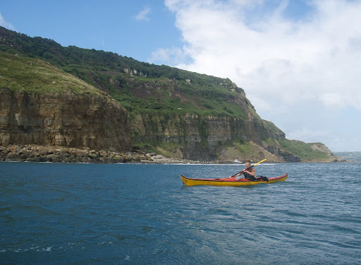
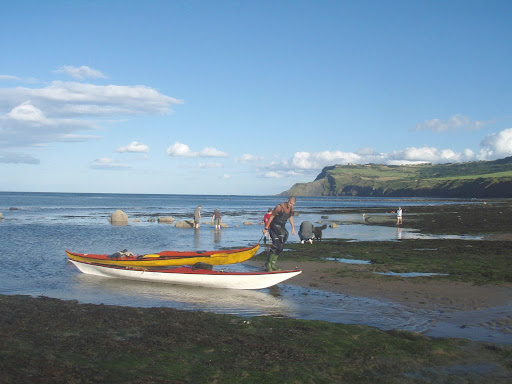
Robin Hood's Bay is lies between Whitby and Scarborough on the Yorkshire coast. The Village is a tightly woven mesh of terracotta roofed houses and narrow streets lining a steep gorge that runs down to the sea. Away from the humdrum is one of the most beloved youth hostels in the UK. Boggle Hole is yet another steep narrow gorge but the only buildings here belong to the youth hostel that bears the same name. The northern extremity of Robin Hoods Bay is marked by 'North Cheek'. The southern extremity is marked by 'South Cheek'. Boggle Hole is mid-way between the two (don't bother with answers on a postcard).

Ian and I paddled from the 'hole' and out past the seal infested South Cheek and continued south on our 10km trip towards Scarborough. The cliffs beneath Ravenscar are far more spectacular than I had anticipated. They rise to more than 160 metres and are well vegetated with trees, bracken and heather. Names like 'Beast Cliff' and 'Rodger Trod' added to the anticipation of the journey as force 5 winds whistled over the cliffs round our ears and out to sea. As we made our way past the sheltered bays at Hayburn and Cloughton Wykes there was no sign of civilization nor any clue as to the culture shock awaiting us upon our arrival at Scarborough. Upon arrival we did as Romans and engaged in the seaside promenade culture. One cup of tea and a whippy 99 ice cream laid the foundations for fuelling the return journey through the wilderness to Robin Hoods Bay. Although the wind funnelled strongly from the valley dealing us a proctalgic slog into the bay, it was not enough to prevent us from landing perfectly between 'the cheeks' safely back at Boggle hole.

Tuesday, August 05, 2008

Crossing Morecambe Bay #2 (heading South)

Following the success of the journey north, our return to The Fylde Coast from Piel Island was to be a little more of a challenge. Our target this time was to be Fleetwood. Strong coffee and tea were consumed to boost our resolve. The prospect at carrying our boats to the low water was almost enough to keep us in bed! But by 9-00am were were paddling out of the Piel Channel against the incoming tide and out into Morecambe Bay.

By the time were making our way out past the outer channel marks at South East Walney we were struggling to make any headway at all and the gloomy skies did little to lift our spirits.

As we turned to make for Fleetwood we aimed our bows due south using Blackpool Tower as a visual reference and all seemed well for a while. After about an hour it was becoming clear that it was going to take much more time and effort to reach Fleetwood than we anticipated, despite the shorter distance.

We were being swept east faster than we had thought likely. The westerly breeze wasn't helping matters and conditions in some of the overfalls were both challenging and exhilarating (sorry no photos). We were unintentionally approaching the hungry jaws of the Lune Estuary when we found renewed resolve during a mars bar break, just as the tide began to loosen its grip on us.

After over four and a half hours on the waters of Morecambe Bay Peter and I arrived exhausted but relieved on Fleetwood Beach. Although some small children helped us to carry our boats ashore we still didn't have the strength for a pint at the conveniently situated 'Wyre Lounge Bar'.

Saturday, August 02, 2008

Crossing Morecambe Bay #1 (heading North)

With the aim of reching Piel Island near Barrow in Furness, Peter and I set off from Rossall near Cleveleys on the north Fylde Coast this Morning. The crossing involves making a 20 km ferryglide accross the powerful flood tides of Morecambe Bay.

The water was choppy right from the start and even leaving the beach presented its difficulties.Conditions remained choppy for most of the crossing and we encountered some more challenging overfalls before we had reached the half way point. The second half of the crossing was in some ways easier but with a littltiedness setting in I was finding it difficult to maintain a good pace and my cockpit plenty of water.Eventually after 3 hours and 25 minutes Peter and I arrived on the eastern shore of Piel Island and I discovered why my boat had been so sluggish. I had not fully sealed the rear hatch cover and most of my posessions were floating around gently in plenty of Irish Sea water!

Sunday, July 27, 2008

Fish Chips and Mushy Peasoup

In search of adventure, I met with Dave and Jules at the Yorkshire seaside town of Filey to paddle along the coast to Scarborough. I had never ventured along this stretch of coastline before and having now made a successful return journey, I feel very much none the wiser.

Shortly after leaving the beach in pleasant morning sunshine we ventured around the Filey Brigg, which is the headland and reef the forms the northern end of Filey bay. Within minutes we found ourselves in choppy conditions with dense fog locally known as 'sea fret' descending dramatically allowing us to see less than 50 metres at times. The sea conditions soon relented but it was difficult to see the shore. Pinpointing our position was tricky making map and compass essential and GPS quite reassuring.

Our 16km trip was plagued by the fret for all but the last 2 km of the approach to Scarborough where we were landed in brilliant sunshine amongst crowds of holidaymakers indulging in the great British seaside tradition of sandcastles, deckchairs and knotted hanky head wear. We opted for another great British seaside institution - Fish and Chips! It was hoped that adding mushy peas to the equation we might please the gods in the hope that they would leave our return journey clear.

It is now clear that we got that one quite wrong! Within minutes of leaving Scarborough we were paddling in fog thicker than before, making route finding amongst the reefs beneath Grissthorpe Cliff quite tricky.

Eventually we found Filey Brigg and the only challenge between us and a safe return. The north going tidal stream combined with some gentle swell to give us a roller coaster ride into Filey Bay where the mist promptly cleared allowing us to find our cars and, more importantly a tea shop.

Saturday, July 12, 2008

Chorlton Beer Feshtival

I live in a suburb of south Manchester called Chorlton-cum-Hardy. The name is sometimes subject to ridicule but I rather like, and am proud of it as I have lived most of my life here.

I also like beer, especially real ale so I pleased to report that the 4th annual Chorlton Beer Festival has ended in proud fashion with all barrels empty before church bells could ring 'closing time'.

Monday, June 23, 2008

The windy way round the island of Walney

I had originally planned for an overnight trip to camp at Peil Island and paddle round Walney. These plans were all but abandoned due to the onset of some pretty foul weather. Nevertheless Mark insisted on not staying at home and completing another circumnavigation just the same. We were joined by Bill & Royanne who met us at the village of Biggar on the island of Walney.

We started from the west shore at 'Cross Dike Scar' and paddled round the south east point amongst plenty of chop and swell generated by the strengthening force 4 southeasterly wind and opposing tidal currents.

We landed briefly on Peil Island to make sort out misplaced footrests, jammed skegs and other associated maintenance . Mark and I found time for a swift half at the Ship Inn too!

The flooding tide and freshening force 5 (gusts of 6/7) wind rushed us up the Walney Channel. It seemed that all we had to do is steer and surf all the way to the shelter of North End Haws where we took a short sandwich and chocolate break.

Progress along the west shore was fine at first in the lee shelter and with some assistance from the ebb tide. As time went on, and as the coastline turned more southeasterly our progress slowed. The last 2km took nearly half an hour!

In the interests of keeping with tradition the post circumnavigation briefing was adjourned to the nearest pub. The Queens Arms at Biggar was perfect!

Monday, June 02, 2008

Strong winds and a change of plan

I took the whit week off work with a plan to paddle north along the east coast from Yorkshire to the Scottish border. With the winds forecast to be east or northeast force 4-6 for most of the week, the chances of making it from Flamborough Head to the Scottish border in one piece weren't good. Tide tables were consulted and following some head scratching we made a last minute decision to start the week with some paddling on the southwest Lake District coast.

I was joined by my friends Glen and Andy. We started at
Arnside following the shallows of the Kent Channel into Morecambe Bay where we met the rising waters of the incoming tide. Once we had waited out the initial rush we turned west and made an 18km crossing from Kent Bank to Piel Island.

We made camp for a couple of days to weather out the strongest of the strong easterlies.

Ravenglass on the west Cumbrian coast was our next destination and having endured all of the fresh air one could wish for on Piel, the serenity and shelter of Ravenglass was well appreciated. High tides were in the evening and early morning so we took the opportunity of paddling up one of the estuaries to find a quiet spot to camp for the night.

As the winds dropped we took a paddle from Whitehaven to look at the cliffs at St Bees Head before heading over to the east coast via Ullswater.

Our first paddle on the east coast was a trip down the tidal section of the River Tyne following the ebbing tide through the city of Newcastle beneath the historic bridges old and new.

As the swell on the North Sea was dying away we decided to brave the
Northumbria Coast with our final day of paddling. We paddled from the beach just behind the post office at Beadnell to Warkworth Beach just over a mile to the north of Amble. A strong northerly wind kept our hands firmly on the loom for most of the journey and especially through an exciting surf landing at the end of the day.

Its a shame we couldn't finish the objective, but that's difficult if the weather conditions won't even let you begin.

There are more photos of the trip to be seen here.

Thursday, May 22, 2008

Hurrah!

I'm waking up like I did almost exactly 9 years ago with a warm feeling attempting to cross swords with the beginnings of a vengeful, blistering hangover . The breakfast TV headlines seem to make re-living last nights victory in Europe fantastic, but life goes on and I now have to prepare for a day at work. In the meantime the complex planning for a sea kayaking trip goes on in the face of a forecast of typically British bank holiday bad weather.

Wednesday, May 21, 2008

A View From Above

The tiredness that followed the previous weekend's crossing to the Isle of Man continued into last weekend. Fortunately the gentle northerly breeze cleared up the visibility on the east coast so I headed off for Eddsfield Airfield near Bridlington where I have made some friends. Bill and I took off early in the morning heading for Holy Island off the Northumberland Coast.

This is such a fantastic way to view the coastline (or any other landscape for that matter).

We followed the northumberland coast along through Cleveland and North Yorkshire. When we rouded the headland at Scarborough we called ahead to Eddsfield to let them know that we would be arriving shortly and also to request a couple of bacon butties.

Cheers to Bill and all of the rest of the helpful & friendly folk at Eddsfield Airfield.

There are more photos from this flight to be viewed here.

Wednesday, May 14, 2008

Double Kayak to the Isle of Man

Following a changeable Bank Holiday weekend the weather started to show signs of settling down a little. With this in mind Sean and I began finalising some long term plans for a crossing from St Bees in west Cumbria to Ramsey on the Isle of Man.
The Distance is 53 km, 33 Statute Miles or 28 Nautical Miles. I sent a fax to Liverpool Coastguard advising them of the details and booked the campsite next to the beach at St Bees, and some basic bunkhouse accommodation at The Venture Centre on the Isle of Man.


Kirstine generously volunteered to drive us to St Bees, act as a shore contact and wait around for the weekend in case we decided to return by the same means on the following day.

The tides dictated that we had to leave St Bees in the pre-dawn darkness at 3.30am. We expected the crossing to take 6-8 hours. I reported our position and average speed to the coastguard periodically so that we could be advised of any collision risk and as dawn broke we realised that visibility was only a mile or two at best.

From an almost flat calm at St Bees the wind rose to a northwest force 4 giving quite choppy conditions making the boat a little tricky to handle.


Shortly after reporting in to the coastguard for the second time we saw a ferry pass about a mile in front of us then disappear back into the gloom. Our only other encounter with boats was with a sailing boat appropriately called ‘Night Cat’ around 5 miles from the Manx coast. The helpful skipper called across to us offering a bacon butty then pointing a finger west by southwest into the mist declaring that to be the way to Ramsey.

It wasn’t until we were within less than two miles of Maughold Head that we got our first real sight of land and after 6 hours and 15 minutes we landed on the seaweed infested rocky foreshore of Maughold Brooghs. After a short break we continued to our final destination, Port E Vullen where we unpacked the kayak and made our way for s well-earned rest at the near by Venture Centre.

The forecast for the following day gave easterly force 3-4 so rather than a slog into a headwind we decided on a more leisurely paddle along the coast to Douglas and catch the 3 o’clock fast ferry to Liverpool. Following a log like sleep we enjoyed a hearty breakfast of cheese toasties, grapefruit and muffins before setting off for the beach. Ahead of us lay a 26km paddle along some of the best lcoastline that the Isle of Man has to offer.Photo: Sean Jesson

The paddling was uneventful and by Lunchtime we had landed close to the ferry terminal in readiness for an easier crossing. The ever helpful Kirstine met us on our arrival at Liverpool and we were all home in time for Tea.

Tuesday, May 06, 2008

Bank Holiday Paddling

On Saturday Kirstine and I set off early to expolre the Kent Estuary at Arnsinde on the Lancashire coast. We just missed the Bore, saw plenty of wading birds, Swans and Shelduck, and managed to confirm that the chippy at Arnside provides excellent apres paddle.

Me, Sean, Clive, Lesley and Andy completed the Lancaster Round on a dull and wet Sunday. The Route starts at Glasson Dock where we took the last of the flood tide up the Lune Estuary into Lancaster. Following a couple of awkward portages we paddled along the Lancaster Canal through Lancaster where we stopped for a generous pub lunch.The re-fuelling proved sufficient for the return to Glasson via Galgate, including providing some help to an Ambulance crew needing to carry an elderly lady with an injured leg, over a kilometre to the nearest road access.

Finally, on Monday Kirstine Chris and I completed a sunny 20 mile circumnavigation of Walney Island. Before returning to the mainland we visited Piel Island to congratulate the newly enthroned King who is keen for visitors to come on beer drinking raids.