Tuesday, September 16, 2014

Winding Back

Over the last few days we re-traced our route to Sermiligaaq visiting our previous camps on the islands of Storø and Gruse. With time in hand we could explore the remains of old Eskimo settlements and hike up onto the high ridges to take in the expansive views.


Soon after we entered the network of channels that lead from Sermiligaaq to Tasiilaq we stopped to explore the abandoned US air base known as Bluie East 2.


Bluie East 2 was hurriedly abandoned in the early 1950s. The local hunting communities made good use of the furniture and fuel that was left behind. Some of the truck engines remain in use to this day on fishing boats. The trucks, mangled hangar and some 100,000 oil drums make up a bizarre rusting wasteland that stands as a decaying reminder of the 'Cold War'. A blot in an otherwise pristine sub-Arctic wilderness.

A forecast of poor weather combined with news of a volcanic eruption prompted us to make a dash for Tasiilaq in order to wind things up and sort out our kit before strong winds and heavy rain would make this task a great effort.


It was a bit of an anti climax to return early but the underlying memory is of an expedition to a majestic coastline with such scale that I could not have imagined. The glaciers, the cliffs, the bergs and the Northern Lights were all so much beyond what my dreams could conjure up. 


As for Lake Fjord and the Watkins memorial, they will be there for another time and another adventure... Finally, I'd like to pass on my thanks to Martin Rickard at Sea Kayak Adventures for his impeccable guidance and  logistics arrangements, Clif Bar & Company for keeping us all in healthy & nutritious snacks, Lyon Equipment for support with Ortlieb dry bags and Trek 'n Eat expedition meals, Mitchell Blades for my excellent 4-piece Bombora paddles and finally to Peak UK and P&H Custom Sea Kayaks for their continued support.

Monday, September 15, 2014

Waterfall Valley & Glacier de France

The combination of sheltered waters and sunny weather made for almost Mediterranean conditions in Kangertittivatsiaq Fjord. It it baffling to feel too hot whilst paddling amongst ice. 


We finished the day two thirds of the way up the fjord on a beach with flat rocks that were warm from the day's sunshine. Between preparing food and pitching our tents we spent an hour or so sunbathing. 


To add to the paradise feel of our camp there was a raging river cascading over ledges and sliding over smooth slabs. As paddlers, we spent a while discussing the best white water lines down there impossible rapids and drops.


Before the sun went down behind the northern end of the fjord we followed the river further up the valley and wondered when people were last here.

When morning came we paddled for almost three hours towards the calving face of Glacier de France. The scale of this landscape was difficult to comprehend. I gazed beyond the fragile ice cliff and across the surface of the glacier stretching, twisting and curving for mile upon mile towards the mountains in the hazy distance. The most distant mountains were well off our map and north of the Artcic Circle.

This place was peaceful and quiet apart from the 'snap crackle and pop' from the brash. As the strong morning sun warms up small pieces of ice, tiny pressurised air bubbles burst as the surfaces melt. The fizzing and popping sound is amazing. Like paddling through a giant bowl of ‘Rice Crispies’. The ice kept us buzy as we turned to paddle south and continue our journey. From now onwards we would be working our way back towards Sermiligaaq and eventually Tasiilaq.

Thursday, September 11, 2014

Northern Lights

We found a great place to camp less than 2 hours paddling east from our 'retreat beach'. There was fresh water, plenty of space for tents and an excellent view. We had landed earlier than normal so there was plenty of time to relax and enjoy our surroundings. Two brave souls even took to the icy waters for a spot of Arctic skinny dipping. Brrrr!

I took a dim view of the aquatic daredevilry and went to bed early as I would need to be up at 1am for my 'bearwatch' shift. As soon as I got up I was surprised as to how dark it seemed. In mid August the nights get progressively darker at an alarming rate.

I stood on a rocky knoll and did a sweep of the nearby shore with the main beam of my headtorch. I must have been feeling a little on edge because I nearly jumped out of my skin when my torch picked out a particularly pale (bear-shaped) boulder on the beach. I put on my stove to make a cup of hot chocolate to settle my nerves. It was then that I noticed a pale green stripe gently moving across the dark blue sky. It grew into a collection of broad shafts of light that waved and curled like a curtain caught in a breeze. I had been staring long enough for the water on my stove to boil over. Thankfully there were no bears sneaking around camp.

In the Morning all we could talk about was the fantastic light show but it was time to head North-West for our consolation prize; a couple of days exploring Kangertittivatsiaq fjord and the calving face of Glacier de France.

Wednesday, September 10, 2014

Hell Corner


The team rose early soon after the sun rose into the blue morning sky. The sea was calmer and the weather forecast favourable. The northern tip of Storø is around 10 kilometres across a wide channel from the beginning of a 30 kilometre stretch of coastline dubbed 'Hell Corner' by Watkins' 1930s expeditions.

The closer we got the greater the swell became. As we approached the first major headland the waters became choppier than we had seen on this trip. Several huge bergs that were surging in the swell gave us only limited room to get through, or around.

http://ocean.dmi.dk/arctic/ammassalik.uk.php
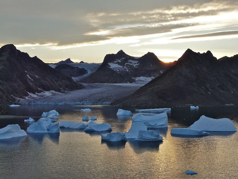
Normally, there would also be bands of pack ice sitting just offshore. The presence of pack ice serves as a slowly drifting breakwater and dampens off much of the energy from the swell. It is also possible to land on these flat fragments of frozen ocean to rest on long passages. On this occasion the pack ice was gone. Only huge bergs remained leaving our route around 'Hell Corner' exposed to the undiluted power of the Denmark Strait.

There group had gone a bit quiet. There was none of the usual chatty banter. A decision needed to be made and agreed upon so we rafted up.  Even holding the kayaks together was tricky as they banged together in the surging choppy sea.  With a further 30 kilometres of committing paddling to go, there was insufficient confidence to go ahead, especially as we had only a vague forecast for the return.  Reluctantly, we decided to retreat to a beach that we had passed some 40 minutes earlier.

We landed through surf onto a broad pebbly beach in a bay that was littered ice fragments. We took our time to eat, rest and recuperate. If we were to abandon our plans to reach Tugtilik, we would need to identify a new objective. In the meantime, somewhere to camp would be good too...


Sunday, September 07, 2014

Storø

Having filled up our water containers from some melting snowpack on Depot Island, a gentle southerly breeze followed us out of the channel that led out to the open sea. The ocean swell was powerful as it crashed into the foot of the huge cliffs and surged around huge icebergs.

Progressively choppy seas greeted us at each new headland and as we paddled into shadow it felt progressively cold too.

It was with a great sense of relief that we reached the southern tip of Storø at around 6pm. Storø means big island in Danish and with its towering peaks and ridges reaching to over 800 metres it certainly lives up to its name.

Our relief was short-lived as we realized that our camp for the night in one of the northern bays was still over 2 hours paddling away. The warmth of the sun had all but gone by the time of our arrival. Fortunately, the 2 hunting cabins that we had been told about were in reasonably good condition so there was no need for us to pitch any tents. There were also some scraps of wood so we quickly made a fire. This not only kept the evening chill at bay but meant that we could save fuel by cooking on it.

Friday, September 05, 2014

Depot Island

The early morning sunshine took its time spilling over the hill onto our west-facing camp. By the time we felt the sun's warmth, the glaciers across the water shining in its brilliance for more than 2 hours.
Smooth waters and light winds welcomed us onto the sea under a brilliant Arctic blue sky. Half way to our lunch stop we past some small islands and skerries. Out across the shimmering sea yet another island chain with towering peaks stretched into the sky. These chains of off-lying islands gave our passage a great deal of protection from the powerful swell in the Denmark Strait.

The further we paddled North, the more gigantic the coastline became. To the west lay deep inlets with calving glaciers stretching way inland. As we rounded the last major headland before our lunch stop on Depot Island, a chilly breeze began to creep in from the North. At first I thought that it may be one of those temporary gentle gusts that would last a few minutes. The breeze gained momentum until it was a steady force 4 scattering white-caps all around us. We altered course to get some shelter behind the headland on Depot Island that would be our lunch stop.

We scratched our way around the most easterly point onto a narrow pebbly beach. Realising that we would be there until the wind dropped, we got out our stoves and made plenty of steaming hot drinks. In the meantime 2 of the group who had plenty of energy continued around the north part of the island to scout ahead and look for water.

The wind continued for the rest of the day occasionally switching direction. Sometimes it would be Easterly and sometimes from the south. Either way, our lunch stop soon became our camp for the night. There was adequate space for tents but the pebbly beach that we had landed on at low water soon became flooded at the water rose. It was difficult to tell exactly how high the water would come and we ended up repeatedly shifting our kayaks higher and higher up the rocks until the time for high water has passed.
 

Monday, September 01, 2014

Stepping Off

There had been a steady breeze from the sea since we landed. This brought a penetrating chill that reminded me that we were in a lonely Arctic wilderness.  I had been cold all night. I was woken at 5am for my hour long 'bearwatch' shift. I made myself a cup of hot chocolate and huddled behind a boulder whilst watching, waiting and hoping for nothing to happen. After my shift, I felt the benefit of the warm drink and got a couple of more hours in the land of nod.

Paddling from our first camp filled us with excitement and anticipation. The wind had abated, the morning sun warmed the air and gave the bergs a bright, fresh new look. The peak of the first exposed headland towered nearly 700 metres over the calm ocean. The sheer scale of the scenery was difficult to comprehend. We didn't land until lunchtime.

The rest of the day's paddle was less exposed with the sparkling coastal waters protected by a series of off-lying islands with peaks rising sharply to over 500 metres. We landed in the late afternoon sunshine on a sandy beach at the island of Gruse. To the east there was only open ocean with small groups of icebergs.

To the west, the steep mountainous coastline was dissected by immense calving glaciers. Every now and then, a huge piece the size of a block of flats would crash into the sea. This would give a thunderous boom shattering the peace of what had become a still and silent evening.

In the distance to the north we could make out Ailsa Island and our crux headland dubbed 'Hell Corner' by the 1932 British Air Route Expedition team. We were stepping off into territory where few choose to venture.